Lots of weird things going on... weird clouds, weird weather, weird events in the ground, in the sky...
Enjoy!
 |
| Source: Zack Labe |


Victoria has copped the worst September deluge in a century triggering landslides along the Great Ocean Road, evacuations and school closures.
The wild weather affected 12 council areas, with 102 roads shut, seven schools closed and 14 bus routes disrupted on Wednesday. Emergency services conducted 11 rescues in floodwaters.
A 50-kilometre stretch of the Great Ocean Road, between Moggs Creek and Skenes Creek, remains closed due to a series of landslips and fallen trees.
Ballarat has experienced it wettest three days since 1921, while Beaufort received the most rainfall it's had in a 72-hour period since 1911, and Wedderburn since 1916.
The rain is continuing here today and the weather has been rather feral over the past week. Looking out the window into the valley below there are huge pools of water in paddocks and the local river has clearly flooded. Fortunately, there hasn't been any major damage, the bridge deck is still higher than the floodwater and livestock appears to have been moved to higher ground well in advance. I have noticed that a couple of unexpected springs are producing crystal clear water in odd spots about the farm and I have taken note of those spots. One of the unexpected springs flooded my firewood storage, so it was a prudent investment of my time to build and fill a second firewood shed. I’m slowing down on the consumption of firewood as things warm up anyway.
 |
| Source: ThinkProgress-Climate. |
We appear to be in the midst of the long-awaited jump in global temperatures.
And that means “The kinds of extreme weather we have seen over the past year or so will be routine all too soon, but then even worse records will be set,” as Kevin Trenberth, one of the world’s leading climatologists, told me.
NASA has reported that last month was not merely “the warmest August in 136 years of modern record-keeping,” it tied with this July 2016 for the “warmest month ever recorded.” And for 11 straight months (starting October 2015), the world has set a new monthly record for high temperature.
So even though 2014 set the record at the time for the hottest year — and then 2015 crushed that record, NASA says there is a greater than 99 percent chance 2016 will top 2015. And it probably won’t be close ...
 |
| Source: National Hurricane Center via Brevard Times. |
 |
| Source: South Florida Water Management District via Brevard Times. |
 |
| Source: National Hurricane Center. |
 |
| Source: Weather Underground. |
 |
| Left. |
 |
| Centre. |
 |
| Right. |
 |
| Left. |
 |
| Centre. |
 |
| Right and at an angle to catch the overhead. |
 |
| GOES Satellite Image. Source: NFSC NOAA |
 |
| Forecast location and intensity by simulated IR brightness temp. for August 29th, 2016 at 09z (UTC = 4 AM CDT) Source: TropicalTidbits.com |
 |
| Forecast location and intensity by composite reflectivity (dBZ) and mean sea level pressure (mb) for August 29th, 2016 at 09z (UTC = 4 AM CDT). N. B.: dBZ = decibels and mb = millibars. Source: TropicalTidbits.com |
 |
| MSLP model forecast for North America on Friday, September 1 2016 0:00 UTC (GMT = 7 PM August 31st CDT). Source: Centre Meteo UQAM Montreal |
 |
| Seven-day forecast map starting August 29, 2016 at 0:00 UTC (7 PM CDT August 28). Source: ECMWF.IFS |
 |
| Source: Weather Underground. |
 |
| Source: PBS.org. |
 |
| Image source: Tropical Tidbits. |
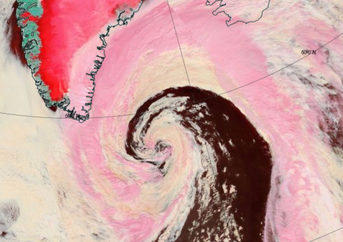
CMC 10-day forecast model run showing an extremely powerful 955-mb low just north of Svalbard on August 25th. Such a storm is low-probability at this time, but its formation would likely result in serious impacts to sea ice. (Robertscribbler)Meanwhile there's another cyclone that came out of Siberia via the Laptev Sea, and is coming up right up by the North Pole, stronger than the one off of Greenland.
 |
| "Great Arctic Cyclone" of 2016 as of yesterday, August 15th. Image source: LANCE MODIS. |
 |
| Also yesterday. Image source: Earth Nullschool. |
Storms, heat and moisture feed up through a high-amplitude wave in the Jet Stream over northern Europe and Siberia and into a developing Arctic cyclone over the Laptev Sea during the early hours of August 15, 2016.
Central pressures in the storm fell to 969 millibars and the winds whipping out over the Laptev, East Siberian, and central Arctic waters gusted at 45 to 55 miles per hour. Waves of 6 to 10 feet or higher roared through the newly-opened waters filled with increasingly dispersed ice floes. (Robertscribbler)Since then the storm's strongest winds have calmed down to about 42 kmph, which is just north of 25 mph.
|
| Source: PBS.org. |
|
| Image source: Tropical Tidbits. |
CMC 10-day forecast model run showing an extremely powerful 955-mb low just north of Svalbard on August 25th. Such a storm is low-probability at this time, but its formation would likely result in serious impacts to sea ice. (Robertscribbler)Meanwhile there's another cyclone that came out of Siberia via the Laptev Sea, and is coming up right up by the North Pole, stronger than the one off of Greenland.
|
| "Great Arctic Cyclone" of 2016 as of yesterday, August 15th. Image source: LANCE MODIS. |
|
| Also yesterday. Image source: Earth Nullschool. |
Storms, heat and moisture feed up through a high-amplitude wave in the Jet Stream over northern Europe and Siberia and into a developing Arctic cyclone over the Laptev Sea during the early hours of August 15, 2016.
Central pressures in the storm fell to 969 millibars and the winds whipping out over the Laptev, East Siberian, and central Arctic waters gusted at 45 to 55 miles per hour. Waves of 6 to 10 feet or higher roared through the newly-opened waters filled with increasingly dispersed ice floes. (Robertscribbler)Since then the storm's strongest winds have calmed down to about 42 kmph, which is just north of 25 mph.
 |
| Source: NBC News |
 |
| Rouses Supermarket in Denham Springs is invaded by SIX FEET of floodwater. Only the top roofs of the SUVs are showing. Source: Rouses via Nola.com. |
 |
| Taken at 7:38 PM. |
 |
| Taken at 7:54 PM |
 |
| Taken at 7:55 PM |
 |
| July 30 2016 8:30 PM - Thundercloud with white spot to the left. |
 |
| 8:31 PM - In relation to Sunset - white spot marked out with red circle and arrow. |
 |
| 8:32 PM - Close-up of light spot |
 |
| 8:32 PM - In relation to the Sunset. |
 |
| Photo taken July 29, 2016 at 7:30 PM |
 |
| Feedbacks and Peak Fossil Fuel Emissions. Source: Sam Caranas, Arctic News. |
 |
| July 3, 2016 7:52 PM, before sunset. |
 |
| July 9, 2016 7:04 PM - before sunset. |
 |
| July 9, 2016 7:04 PM -- seconds later. Note weird clouds in the sky. |
 |
| July 9, 2016 7:05 PM -- camera upturned from cloud in above photo. |
 |
| July 10, 2016 1:03 PM -- blue sky between dark storm clouds. |
 |
| July 10, 2016 8:26 PM -- after sunset. |
 |
| July 10, 2016 8:26 PM -- a few seconds later. |
70.8 North, 69.2 East. It’s the Lat, Long coordinate location of a section of the Yamal Peninsula in Siberian Russia. A typically chilly region of frozen but now thawing ground more than 4 degrees of Latitude north of the Arctic Circle. A place that saw the appearance of odd, disturbing (and now controversial) methane blowholes pockmarking the melting permafrost during 2014. Today, the high temperature in a land now being forced to rapidly warm by human-caused climate change spiked to a tropical 80 degrees Fahrenheit (26.4 C)at 0800 UTC. Tomorrow, temperatures are expected to again rise to 80 F (26.5 C). And in the same location on Thursday, the mercury is forecast to strike close to 86 F (30 C).
Across the Arctic Ocean at Latitude 71.4 North and Longitude 111.7 West, Canada’s Victoria Island is today also seeing temperatures spike to near 80 F (26.8 C). It’s a place encircled by sounds of wet crackling and fluid sighs. The mournful songs of melting sea ice. A sad threnody for the end of a much more stable and hospitable climate age. And there, and even further north to Banks Island, readings are expected to range from 80 to 82 F (26.7 to 27.7 C) on Wednesday and into Thursday.
 |
| Pyrocumulus cloud near Fort McMurray, Alberta, Canada earlier this year. Previously posted at Robertscribbler. |
 |
| Taken June 29, 2016 at 6:38 PM Sun looks like it's in the north-northwest. |
 |
| Taken at the same day and time. The Sun is supposed to be above, inline with the tree. |
 |
| Taken same day at 7:55 PM just before Sunset. Sunlight appears in the northwest to northeast, across the sky. |
 |
| Taken same day at 8:18 PM, quarter hour after Sunset. Note the pink light behind the cloud off to the northeast. |
 |
| Same day, same time. The Sun appears to be in the northwest! |
 |
| Same day, same time. Here's where the Sun is supposed to have set -- behind the big tree! |
 |
| Taken July 1, 2016 at 8:27 PM Just after Sunset. These clouds are weird -- they look like they are formed from passenger jet chemtrails! |
 |
| Same day, two minutes later. There's this white and grey cloud in front of a pink sky! It was very pale blue with grey margins about five minutes before! (Couldn't get a good photo of that -- iPhone camera and window screen in the way) |