The skies are especially weird in this one!
2016 is strange.
 |
| Source: PBS.org. |
 |
| Image source: Tropical Tidbits. |
CMC 10-day forecast model run showing an extremely powerful 955-mb low just north of Svalbard on August 25th. Such a storm is low-probability at this time, but its formation would likely result in serious impacts to sea ice. (Robertscribbler)Meanwhile there's another cyclone that came out of Siberia via the Laptev Sea, and is coming up right up by the North Pole, stronger than the one off of Greenland.
 |
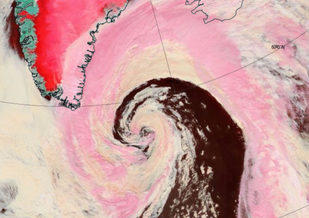
| "Great Arctic Cyclone" of 2016 as of yesterday, August 15th. Image source: LANCE MODIS. |
 |
| Also yesterday. Image source: Earth Nullschool. |
Storms, heat and moisture feed up through a high-amplitude wave in the Jet Stream over northern Europe and Siberia and into a developing Arctic cyclone over the Laptev Sea during the early hours of August 15, 2016.
Central pressures in the storm fell to 969 millibars and the winds whipping out over the Laptev, East Siberian, and central Arctic waters gusted at 45 to 55 miles per hour. Waves of 6 to 10 feet or higher roared through the newly-opened waters filled with increasingly dispersed ice floes. (Robertscribbler)Since then the storm's strongest winds have calmed down to about 42 kmph, which is just north of 25 mph.
|
| Source: PBS.org. |
|
| Image source: Tropical Tidbits. |
CMC 10-day forecast model run showing an extremely powerful 955-mb low just north of Svalbard on August 25th. Such a storm is low-probability at this time, but its formation would likely result in serious impacts to sea ice. (Robertscribbler)Meanwhile there's another cyclone that came out of Siberia via the Laptev Sea, and is coming up right up by the North Pole, stronger than the one off of Greenland.
|
| "Great Arctic Cyclone" of 2016 as of yesterday, August 15th. Image source: LANCE MODIS. |
|
| Also yesterday. Image source: Earth Nullschool. |
Storms, heat and moisture feed up through a high-amplitude wave in the Jet Stream over northern Europe and Siberia and into a developing Arctic cyclone over the Laptev Sea during the early hours of August 15, 2016.
Central pressures in the storm fell to 969 millibars and the winds whipping out over the Laptev, East Siberian, and central Arctic waters gusted at 45 to 55 miles per hour. Waves of 6 to 10 feet or higher roared through the newly-opened waters filled with increasingly dispersed ice floes. (Robertscribbler)Since then the storm's strongest winds have calmed down to about 42 kmph, which is just north of 25 mph.
 |
| Feedbacks and Peak Fossil Fuel Emissions. Source: Sam Caranas, Arctic News. |
70.8 North, 69.2 East. It’s the Lat, Long coordinate location of a section of the Yamal Peninsula in Siberian Russia. A typically chilly region of frozen but now thawing ground more than 4 degrees of Latitude north of the Arctic Circle. A place that saw the appearance of odd, disturbing (and now controversial) methane blowholes pockmarking the melting permafrost during 2014. Today, the high temperature in a land now being forced to rapidly warm by human-caused climate change spiked to a tropical 80 degrees Fahrenheit (26.4 C)at 0800 UTC. Tomorrow, temperatures are expected to again rise to 80 F (26.5 C). And in the same location on Thursday, the mercury is forecast to strike close to 86 F (30 C).
Across the Arctic Ocean at Latitude 71.4 North and Longitude 111.7 West, Canada’s Victoria Island is today also seeing temperatures spike to near 80 F (26.8 C). It’s a place encircled by sounds of wet crackling and fluid sighs. The mournful songs of melting sea ice. A sad threnody for the end of a much more stable and hospitable climate age. And there, and even further north to Banks Island, readings are expected to range from 80 to 82 F (26.7 to 27.7 C) on Wednesday and into Thursday.
 |
| Pyrocumulus cloud near Fort McMurray, Alberta, Canada earlier this year. Previously posted at Robertscribbler. |
It’s as if global warming [Ed-M: global weirding] were ringing the Earth’s atmosphere like some great, cacophonous alarm bell. The upper level zonal winds are swinging wildly from record high positive anomalies to record low negative anomalies. Gravity waves — the kinds of big atmospheric waves that tend to move air from the Tropics all the way to the Poles and are powerful enough to cause the Caribbean Sea to ‘whistle’ in the satellite monitors — are growing larger. And the Jet Stream now has redefined all boundaries — flowing at times from the East Siberian Sea in the Arctic across the Equator and all the way south to West Antarctica.
 |
| South Fork of Northern Jet Stream Caught Crossing the Equator. Source: Earth Nullschool. |
Northern Hemisphere Jet Stream crosses the Equator in this Earth Nullschool screen capture to merge with the Southern Hemisphere Jet Stream. It’s the very picture of weather weirding due to climate change. Something that would absolutely not happen in a normal world. Something, that if it continues, basically threatens seasonal integrity.
The big trough today begins near the Northern Hemisphere Pole. It pulls Arctic air down over Eastern Siberia and into a Pacific Ocean storm track. There, a second big dip in the Jet Stream pulls a crazy loop of this upper air flow further south. And here is where things get really weird — for the upper level river of air that began in the Arctic then makes a jump directly across the Equator.
But our story of a wayward Jet Stream doesn’t end there. The upper level air flow that originated near the North Pole joins with a building Southern Hemisphere Jet Stream ridge pattern over the Southeast Pacific. Feeding into very strong upper level winds, it turns southward into a high amplitude wave that crosses the Horn of South America and slams itself, carrying with it a big pulse of extreme warmth, into the upper level airs over Western Antarctica.For more, click at the link below.
CO2’s Vertigo-Inducing Rate of Rise — In First 5 Months of 2016 Hothouse Gas Concentration Rocketed 3.7 Parts Per Million Above 2015
“Perhaps the most worrisome threat is that because the Arctic is warming so much faster than the globe as a whole, the permafrost — soil that remains frozen year-round — is thawing. As it does, organic matter which is trapped within can decay, and when it does it releases CO2 into the atmosphere, except those places where instead of releasing CO2 it releases CH4.” — Tamino.
With the Northern Hemisphere Pole warming at a rate 2-3 times faster than the rest of the globe, there’s a risk that we start to set off a kind of runaway warming feedback. We may be near that threshold now… God help us if we’ve crossed it…
Image source: NOAA ESRL.
https://robertscribbler.com/2016/06/22/co2s-vertigo-inducing-rate-of-rise-in-first-5-months-of-2016-hothouse-gas-concentration-rocketed-3-7-parts-per-million-above-2015/
Water Knives in the Near Future — 16 Year Drought Brings Lake Mead To New Record Low
It’s been ridiculously hot along the unstoppable shrinking shoreline at Lake Mead. Over the past four days, highs have peaked at a scorching 109 to 111 F (42 to 44 C). Similar heat blasted all up and down the Colorado River Basin, squeezing moisture out of a key water supply for 25 million people in California, Arizona, and Nevada.
Source: NASA.
If you thought the current drought was bad, then this animation will knock your socks off. Loss of soil moisture for the US is ridiculously extreme under business as usual fossil fuel burning in this NASA projection.
https://robertscribbler.com/2016/06/23/water-knives-in-the-near-future-16-year-drought-brings-lake-mead-to-new-record-low/
Bad Rains Fall Across Globe — 700,000 Evacuated in Kyushu Deluge as Worst Flood in 100 Years Inundates West Virginia
In Kyushu, Japan on Friday, government officials urged 700,000 residents to evacuate as record heavy rains and severe flooding inundated the city for the fifth day in a row. Half a world away in West Virginia, another unpredicted record deluge dumped 8.2 inches of rain, washed out roads, cut off shopping malls, flushed burning homes down raging rivers, and left more than 14 people dead and hundreds more stranded.
Individually, these events would be odd. But taken together with what are now scores of other extreme flooding events happening around the world in the space of just a few months and the context begins to look a lot like what scientists expected to happen due to human-forced climate change.
In Kyushu, the skies opened up on Monday. An extension of a seasonal front draped across China and feeding on moisture bleeding off of record hot ocean surfaces edged out over Japan. Mountainous cloud banks unloaded. Record rains in the range of five inches an hour then began to inundate the southern Japanese island. This mass dumping of water eventually accumulated to half a meter (or 1.6 feet) over some sections of the island over the course of just one 24 hour period.
A burning home floats down a West Virginia creek swollen to a raging torrent by the worst flood to hit the state in 100 years.
Numerous homes and hundreds of cars have also been lost due to the flash floods that swept through West Virginia’s valleys. In one instance, a burning house was filmed floating down a river. As a result of the severe and unexpected rains, 44 of the state’s 55 counties have now been declared a disaster area.
These severe flooding events add to those this week occurring in China, Australia, Sri Lanka,Indonesia, and Great Britian over just the past seven days. In addition, extreme floods have swept through Texas, Canada, Central Asia, Europe, Ghana and Argentina over the past couple of months.
The floods occur at a time when global temperatures are just coming off of new record highs during the first part of 2016. Temperatures that, in February peaked near 1.5 degrees Celsius hotter than 1880s averages.
https://robertscribbler.com/2016/06/24/bad-rains-fall-across-globe-700000-evacuated-in-kyushu-deluge-as-worst-flood-in-100-years-inundates-west-virginia/And you know the cause. Ever increasing CO2 built-up in Earth's atmosphere. Cause by combustion of fossil fuels, adding to the Fossil Fuels Derivatives Beast. 2016 is strange.
 |
| Wicked Wildfire started at the Sherpa Ranch and burnt its way to the Rte 101 X-way and threatened an oil refinery in Santa Barbara, all on Wednesday. Image source: Pete Demetriou. |
 |
| Extreme Southwest Heatwave Forecast for Wednesday, June 21st. Source: Pivotal Weather. |

