Friday, May 20, 2016
Thursday, May 19, 2016
2016 IS STRANGE Part 14 // MAY
From Last Messages:
The Fossil Fuels Derivatives Beast (the witches' brew of too much Carbon Dioxide, Methane, Nitrous Oxide, and other greenhouse gases and pollutants in our atmosphere and oceans) is heralding the collapse of industrial civilization with its signals that it's about to act out in a big way -- these are the various signs of the end.
Speaking of Signs of the End... also the latest from Angel of Apocalypse: Signs of the End Part 170.
Enjoy!
2016 is strange.
Monday, May 16, 2016
2016 IS STRANGE Part 13 // MAY
Tornadoes in Europe, fires in Canada and Russia, and more. View the latest from Last Messages. Enjoy!
2016 is strange.
2016 is strange.
Friday, May 13, 2016
Coral Reefs in Florida Keys decimated by acidification.
According to scientists at the University of Miami's Rosenstiel School of Marine and Atmospheric Science, the acidification that's hitting the Florida coral reefs right now is about 35 year of schedule set by the IPCC and previous scientific modeling.
Here's a look:
The UofM scientists did a study of the coral reefs off Biscayne Bay and the Florida Keys and found out that due to ocean acidification, the limestone bedrock of these coral reefs were losing limestone mass faster than the corals themselves can build it back up. As a result, South Florida is losing an important source of fish, tourism revenue and even protection from hurricane storm surges.
From the National Geographic via Robertscribbler:
“ 'Lots of scientists think that ocean acidification is not going to be a problem until 2050 or 2060,' says Chris Langdon, a marine biology professor at the University of Miami’s Rosenstiel School of Marine and Atmospheric Science. 'This is happening now. We’ve just lost 35 years we thought we had to turn things around.' "
More here, here and here.
Here's a look:
 |
| Forty years ago Carysfort Reef, off of Key Largo, was a thriving, thickly settled neighborhood of corals. It was designated a national marine sanctuary. Now the whole area is blighted. Source: Science Daily via Robertscribbler. |
From the National Geographic via Robertscribbler:
“ 'Lots of scientists think that ocean acidification is not going to be a problem until 2050 or 2060,' says Chris Langdon, a marine biology professor at the University of Miami’s Rosenstiel School of Marine and Atmospheric Science. 'This is happening now. We’ve just lost 35 years we thought we had to turn things around.' "
More here, here and here.
Thursday, May 12, 2016
SIGNS OF THE END PART 168 - LATEST EVENTS MAY 2016
From Angel of Apocalypse.
More weird weather, plus a pair of human interest stories in the middle of the vid. I really don't know how a human interest story can be the sign of the end (of our current global American [even Russia is American now] civilization).
Not as cool as Last Messages' vids due to the mainstream media chatter. But still...
2016 IS STRANGE Part 12 // APRIL-MAY
Weird, just off-the-charts type of weather events plus lots of saddening sea and lake creature die-offs.
But the music is cool, and Last Messages placed the die-offs at the end so you can still enjiy the video.
2016 is strange.
.
But the music is cool, and Last Messages placed the die-offs at the end so you can still enjiy the video.
2016 is strange.
Tuesday, May 10, 2016
Yellowstone could put the schnitz on Global Warming.
Instead, it would create a new ice age which would lead to the deaths of BILLIONS of people. And wreck two-thirds of the United States, utterly. Which means the country would not be able to function, period.
In other words: Yellowstone blowing up means the end of America.
From the Inquisitor.com article, Mega-earthquakes in Major Population Centers Highly Imminent, Experts Renew Warning:
For more, click here.
And from another Inquisitor Article, Yellowstone Supervolcano Eruption May Happen Soon; Explosion More Catastrophic than Effects of Climate Change.
For more, click here.
And here's why the Yellowstone Explosion could be huge:
Cross-posted at Fin des Voies Rapides.
In other words: Yellowstone blowing up means the end of America.
From the Inquisitor.com article, Mega-earthquakes in Major Population Centers Highly Imminent, Experts Renew Warning:
Fears have also been expressed about an imminent eruption of the Yellowstone Supervolcano, which experts say experienced a major eruption 640,000 years ago, followed by minor eruptions and lava flows 150,000 and 70,000 years ago, respectively.
Experts warn that major eruptions of Yellowstone comparable to the last super-eruption 640,000 years ago could be up to 2,000 times as powerful as the Mount St. Helens’ 1980 eruption. A major eruption of Yellowstone could devastate large swathes of the U.S. northwest and render about two-thirds of the country uninhabitable.
For more, click here.
And from another Inquisitor Article, Yellowstone Supervolcano Eruption May Happen Soon; Explosion More Catastrophic than Effects of Climate Change.
A Yellowstone supervolcano eruption capable of wiping out the western half of the U.S. may be closer than previously thought. Scientists say the Earth is now in a “volcano season,” and a large volcanic eruption poses a significantly greater global threat than even the effects of climate change.
According to scientists from the European Science Foundation (ESF), the Earth is experiencing a 300-year period of increased volcanic activity, or a volcano season. Some scientists have speculated this increased activity may be due to rising sea levels, possibly related to global warming.
In the report, entitled “Extreme Geohazards: Reducing the Disaster Risk and Increasing Resilience,” experts predict a supervolcano eruption with the ability to kill millions has a five to 10 percent chance of happening within the next 70 to 80 years. Such an event would make it difficult for a global society to adapt and remain sustainable.
Researchers are particularly worried about active volcanoes in Yellowstone National Park in the United States, Mount Vesuvius in Italy, and Popocatépetl in Mexico. As reported by International Business Times, the environmental impact would go well beyond any damaging effects of climate change over a 1,000 year period, should any of these three erupt.
For more, click here.
And here's why the Yellowstone Explosion could be huge:
Cross-posted at Fin des Voies Rapides.
Saturday, May 7, 2016
Wicked Pictures from Alberta's Wicked Wildfire.
Read the article and comments at Robertscribbler. These pics are stolen therefrom.
C'est tout! If you want to see more, go read the article.
 |
| Source: Peter Sinclair via Greg. |
 |
| Source: Andy in SD. |
 |
| Source: Mike Hudema on Twitter via dtlange. |
 |
| Source: Todaysguestis. |
 |
| Source: Greg. |
 |
| Source: cbcerchris at Twitter via dtlange. |
 |
| Source: Greg. |
Friday, May 6, 2016
6 Feet of SLR on the Northern Gulf Coast means New Orleans will be surrounded by water.
Not as bad as South Florida, though.
With just 6 feet of SLR, much or all of THAT place, will be utterly destroyed or made unlivable even if no hurricane or tropical storm hits it. Because of the porous limestone bedrock that's right at the surface, the rising seas will invade the Biscayne Aquifer, depriving the area of its drinking water. Already SEVEN out of EIGHT wells in Hallandale Beach have been invaded by salt water. (Click here.)
For proof, click here and here.
 |
| High Tide flooding on Fort Lauderdale Beach. Source: blog.cleanenergy.org. |
 |
| Hallandale Beach where 7 out of 8 wells are contaminated with seawater. Source: climatecentral.org. |
 |
| Sea-Level Rise and coastal flooding impacts at 6 feet of SLR in South Florida. The Everglades and Broward are gone. Miami-Dade is unlivable. Source: NOAA via blog.ucsusa.org.. |
 |
| And with a 10-foot SLR Miami Beach is inundated. Miami-Dade is utterly destroyed. I guess the elevated Metrorail will become a scenic electric railway, accessible by boat! Source: ClimateCentral.org. |
For proof, click here and here.
Thursday, May 5, 2016
Southern Louisiana faces existential threat from Global Warming.
Reported in The New Orleans Advocate, Sunday, 1 May, 2016.
According to Sunday's article, coastal researchers Donald Boesch and Virginia Burkett, known for their expertise on reasons why the state’s coast is being flooded by the Gulf, present new findings on why Global Warming is the key to whether Southern Louisiana can be saved or not. Their findings reveal that humanity, individually and collectively, must "[k]eep global temperatures from rising more than 2 degrees Celsius (3.6 degrees Fahrenheit) by 2100, and little will change in Antarctica, which means sea-level rise could be manageable and Louisiana’s coastal plan might succeed." Ditto for Greenland.
According to the following Advocate Graphic, keeping to the 2016 COP21 Paris Accords' goal of keeping below 2 degrees Celsius would limit sea level rise to one foot above today's level at the end of this Century. With Business As Usual, the SLR will reach 6 feet globally. When you factor in Peak Oil / Natural Gas / Coal and the coming decline in fossil fuel outputs into BAU, we'll likely see somewhere in between -- unless Greenland and West Antarctica collapse rapidly, then we'll get 42 feet of SLR in a short period of time. This could actually happen! At the end of the last Ice-Age, ice melt from Antarctica led to 14½ meters of SLR per Century for about a thousand years. Total SLR then was 400 feet.

If we fail the COP21 goal, "and the result could be a sudden, dramatic melting of ice on Antarctica, adding another 3 feet to the current prediction of a 3.5-foot rise in sea level by 2100 — an event that would swamp most of the southern third of Louisiana, even if the master plan is implemented."
Here is what 6 feet of SLR in Southern Louisiana looks like. Just 1 foot looks almost as bad.

The Advocate reports, and it's basically true except for the West Antarctic which is melting like Greenland, that:
From the article (boldface emphasis mine):
 |
| Sheets of Runoff fall off the Nansen Ice Shelf in the East End of East Antarctica. |
According to the following Advocate Graphic, keeping to the 2016 COP21 Paris Accords' goal of keeping below 2 degrees Celsius would limit sea level rise to one foot above today's level at the end of this Century. With Business As Usual, the SLR will reach 6 feet globally. When you factor in Peak Oil / Natural Gas / Coal and the coming decline in fossil fuel outputs into BAU, we'll likely see somewhere in between -- unless Greenland and West Antarctica collapse rapidly, then we'll get 42 feet of SLR in a short period of time. This could actually happen! At the end of the last Ice-Age, ice melt from Antarctica led to 14½ meters of SLR per Century for about a thousand years. Total SLR then was 400 feet.

If we fail the COP21 goal, "and the result could be a sudden, dramatic melting of ice on Antarctica, adding another 3 feet to the current prediction of a 3.5-foot rise in sea level by 2100 — an event that would swamp most of the southern third of Louisiana, even if the master plan is implemented."
Here is what 6 feet of SLR in Southern Louisiana looks like. Just 1 foot looks almost as bad.

The Advocate reports, and it's basically true except for the West Antarctic which is melting like Greenland, that:
Antarctica has been melting at a drip. Indeed, the melting of the ice fields of Greenland — on the northern end of the planet — has been much faster. Located in a warmer environment, those ice fields and glaciers have been pouring water into the Arctic Ocean at rates alarming climatologists. Computer models show sea levels would rise almost 20 feet if all the ice in Greenland melts.But there are two monkey wrenches hidden in the Advocate's article, and one is the fact that East Antarctica is beginning to melt like Greenland did less than a decade ago. The other is the effect of gravity on the sloshing sea water in the coming Global Warming induced SLR. What is gravity's effect on sea-level rise in Southern Louisiana?
If all the ice in Antarctica melts, those same models show the oceans would rise 200 feet, meaning Baton Rouge would be on the coast.
From the article (boldface emphasis mine):
Any rise would be even higher on the Louisiana coast because this area would have an increasingly strong gravitational pull as Antarctica lost all that ice, Boesch said.
“So if a certain amount of ice melts and raises global sea level by 1 centimeter, in Louisiana, that rise would be 1.2 or 2.5 centimeters,” he said. “Just another reason why we (in Louisiana) have to be really concerned about these sea-level rise figures.”
So at the maximum translation 1 foot of global sea level rise is 2½ feet, 20 feet of G-SLR is 50 feet, 200 feet, 500 feet. That's a lot of water. At just 12 or 13 feet, with our 32-foot barrier walls and seaward embankments, New Orleans will certainly drown. And Baton Rouge and the rest of the state?
The elevation of Baton Rouge is 83 feet above mean sea level. The elevation of Shreveport, 209 feet above MSL. And the highest point in the state, 535 feet.
Ohhhhh, shit.
The elevation of Baton Rouge is 83 feet above mean sea level. The elevation of Shreveport, 209 feet above MSL. And the highest point in the state, 535 feet.
Ohhhhh, shit.
Wicked wildfire threatens Fort McMurray, Alberta, as other wicked fires burn down Himalayan forests.
 |
| Traffic evacuating Ft McMurray May 4, 2016 to flee wildfires. Note the jams in both directions! |
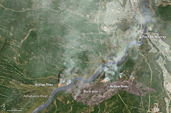 |
| An immense 10,000 ha (25,000 ac.) burn scar, 15 kilometers (10 miles) long. Satellite shot of Fort McMurray Fire and burn scars posted in the NASA twitter feed on Wednesday afternoon. |
A whole city of 88,000 souls (100,000 in the metro area) was under threat from a 25,000 acre wildfire yesterday and probably still is today. The flames might even reach a tar sands processing facility! Ooh, I'd like to see the flames when that goes up. I know I'm being mean, but tar-sands are one of most carbon-heavy type of fossil fuel on the face of this earth, worse than cold, because you need to burn natural gas (methane = CH4) to get the bitumen out of the sands and dilute it so you can transpoirt it via railway or through pipelines; AND, this sort of wildfire is consistent with what the IPCC has determined what has been happening with wildfires as we have been continuing to burn fossil fuels. And if we burn more, and increase the carbon content of Earth's Atmosphere, it'll only get worse.
Wicked red-hot glowing clouds over a subdivision in greater Fort McMurray:

And this is how it look driving out of town on the main highway:
And a nice view of the inferno from a small plane:
 |
| This is the latest from #ymmfire via @CBCNews Photo via @TownSlaveLake #Alberta via Robertscribbler. |
Now on to the other side of the globe:
 |
| Source: Press Trust of India via Robertscribbler. |
The above pic is a fire on a steep, steep slope in the Himalayan Mountains. There are 21,000 fires burning there right now, in 21 Districts in 2 Indian States, and they've consumed in whole or part or threatened 84 villages and two endangered tiger reserves as well as thousands of acres of forests that India had been husbanding and growing back over the decades since they kicked out the Brits. And all they have to fight forest fires is a crew of 9,000 firefighters and increasingly scarce water due to the drought that's parching northern India, thanks to climate change.
More here, here and here.
Tuesday, May 3, 2016
April 30, 2016 is strange.
Severe thunderstorm in New Orleans, La., at 4:07 pm, in New Orleans, La. The lights seen in the vid are from inside the New Orleans Public Library in Lakeview. Enjoy!
2016 is strange.
2016 is strange.
Subscribe to:
Posts (Atom)