Showing posts with label Robertscribbler. Show all posts

Friday, July 8, 2016

Some More Weird Weather.

I'm busy watching Angel of Apocalypse's latest vid. So far I haven't seen anything weird weather-wise.

So I'm going to blurb-reblog four weird weather blogs by Robertscribbler. He can be alarmist at times, but usually he's a good reporter on the global weirding we're experiencing.

Just as Whitley Strieber predicted in The Coming Global Superstorm -- temps in the mid-eighties Fahrenheit on the shores of the Arctic Ocean: Fahrenheit 85.9 Near Arctic Ocean Shores — Extreme Heatwave Settles in Over North-Central Siberia, Canada’s Northern Tier.

70.8 North, 69.2 East. It’s the Lat, Long coordinate location of a section of the Yamal Peninsula in Siberian Russia. A typically chilly region of frozen but now thawing ground more than 4 degrees of Latitude north of the Arctic Circle. A place that saw the appearance of odd, disturbing (and now controversial) methane blowholes pockmarking the melting permafrost during 2014. Today, the high temperature in a land now being forced to rapidly warm by human-caused climate change spiked to a tropical 80 degrees Fahrenheit (26.4 C)at 0800 UTC. Tomorrow, temperatures are expected to again rise to 80 F (26.5 C). And in the same location on Thursday, the mercury is forecast to strike close to 86 F (30 C).
Across the Arctic Ocean at Latitude 71.4 North and Longitude 111.7 West, Canada’s Victoria Island is today also seeing temperatures spike to near 80 F (26.8 C). It’s a place encircled by sounds of wet crackling and fluid sighs. The mournful songs of melting sea ice. A sad threnody for the end of a much more stable and hospitable climate age. And there, and even further north to Banks Island, readings are expected to range from 80 to 82 F (26.7 to 27.7 C) on Wednesday and into Thursday.
For more, click here.

Wednesday Typhoon Nepartak blew up into a Category 5 Super Typhoon -- equal to Category 5 Major Hurricane -- over a Western Pacific Ocean hotspot. The storm came ashore as a Category 4 Super Typhoon after 6:30 a.m. Taiwan local time, Friday morning, It's since crossed Taiwan and weakened to a Category 1 Hurricane Typhoon and is on its way to Southeastern China. Unfortunately, on its projected veering east over China, the storm will rain a lot of rain on parts of China that have already seen really bad -- historic -- flooding.

For more, click here and here.

In Los Estados Unidos Americanos ;^), June was the hottest June on record. For more, click here.

Pyrocumulus cloud near Fort McMurray, Alberta, Canada earlier this year.
Previously posted at Robertscribbler.
Remember the Fort McMurray fire? Well that sort of thing, which can threaten cities, is expected to be rather common in the future, including in Russia, where there are lots and lots of fires in Siberia right now. For more, click here.

Now a link to Angel of Apocalypse's latest. I've finished watching it and found it's very light on weird weather, so I figure it's not worth posting the vid.

2016 is strange.


Wednesday, July 6, 2016

Crikey, Do I Look Like an Idiot!

Remember this post about the Jet Stream doing something weird by crossing the equator?

It turns out that this sort of thing is not unprecedented and not even unusual. In fact, it is a mechanism, one of a few or several, by which the air of the Northern Hemisphere mixes with the air of the Southern Hemisphere. So it actually is something that would happen in a normal world.

However, The Washington Post interviewed Jennifer Francis, professor of meteorology at Rutgers University who specializes in the relationship between global warming and the jet stream and she said that “cross-equator flow cannot be unprecedented, maybe not even all that unusual.”

This broadsheet also interviewed Sam Lillo, who is working toward his PhD in Meteorology at U of Oklahoma and he replied, “None of this is unusual, There isn’t a wall at the equator separating the two hemispheres, and air is free to flow from one side to the other.”

But of course, I uncriticaly reblogged Robertscribbler's article which stated that this was " Something that would absolutely not happen in a normal world," quoting four paragraphs from it verbatim including the above phrase (in quotes), and made myself look like an idiot when the Washington Post article came out. A closer look at the article's first graphic from Earth Nullschool shows that jet stream that branched out and sent a stream crossing the equator was not the polar one at the 80th North parallel, but the subtropical one further south. Now to his credit, Robert has toned down the content of his blog article, parts somewhat, parts considerably.

Now when the Polar Jet Stream really does jump the Equator and join the other polar stream, that would be really, really weird. Possibly even the end of our regular seasons.

I guess it's back to posting Angel of Apocalypse and LastMessage's YouTube videos and even some of my own.

2016 is strange!


Wednesday, June 29, 2016

More Global Weirding - Near Northern Jet Stream Splits, New South Fork Jumps Equator to Join Near Southern Jet Stream.


Gigantic Gravity Waves to Mix Summer with Winter? Wrecked Jet Stream Now Runs from Pole to Pole
It’s as if global warming [Ed-M: global weirding] were ringing the Earth’s atmosphere like some great, cacophonous alarm bell. The upper level zonal winds are swinging wildly from record high positive anomalies to record low negative anomalies. Gravity waves — the kinds of big atmospheric waves that tend to move air from the Tropics all the way to the Poles and are powerful enough to cause the Caribbean Sea to ‘whistle’ in the satellite monitors — are growing larger. And the Jet Stream now has redefined all boundaries — flowing at times from the East Siberian Sea in the Arctic across the Equator and all the way south to West Antarctica.
South Fork of Northern Jet Stream Caught Crossing the Equator. Source: Earth Nullschool. 
Northern Hemisphere Jet Stream crosses the Equator in this Earth Nullschool screen capture to merge with the Southern Hemisphere Jet Stream. It’s the very picture of weather weirding due to climate change. Something that would absolutely not happen in a normal world. Something, that if it continues, basically threatens seasonal integrity.
The big trough today begins near the Northern Hemisphere Pole. It pulls Arctic air down over Eastern Siberia and into a Pacific Ocean storm track. There, a second big dip in the Jet Stream pulls a crazy loop of this upper air flow further south. And here is where things get really weird — for the upper level river of air that began in the Arctic then makes a jump directly across the Equator.
But our story of a wayward Jet Stream doesn’t end there. The upper level air flow that originated near the North Pole joins with a building Southern Hemisphere Jet Stream ridge pattern over the Southeast Pacific. Feeding into very strong upper level winds, it turns southward into a high amplitude wave that crosses the Horn of South America and slams itself, carrying with it a big pulse of extreme warmth, into the upper level airs over Western Antarctica.
For more, click at the link below.

https://robertscribbler.com/2016/06/28/gigantic-gravity-waves-to-mix-winter-with-summer-wrecked-jet-stream-now-runs-from-pole-to-pole/#comment-84471

Monday, June 27, 2016

More Weird Weather from Robertscribbler.

First, the cause of all this global weirding.

CO2’s Vertigo-Inducing Rate of Rise — In First 5 Months of 2016 Hothouse Gas Concentration Rocketed 3.7 Parts Per Million Above 2015 
“Perhaps the most worrisome threat is that because the Arctic is warming so much faster than the globe as a whole, the permafrost — soil that remains frozen year-round — is thawing. As it does, organic matter which is trapped within can decay, and when it does it releases CO2 into the atmosphere, except those places where instead of releasing CO2 it releases CH4.” — Tamino. 
With the Northern Hemisphere Pole warming at a rate 2-3 times faster than the rest of the globe, there’s a risk that we start to set off a kind of runaway warming feedback. We may be near that threshold now… God help us if we’ve crossed it… 
Image source: NOAA ESRL.
https://robertscribbler.com/2016/06/22/co2s-vertigo-inducing-rate-of-rise-in-first-5-months-of-2016-hothouse-gas-concentration-rocketed-3-7-parts-per-million-above-2015/
Now the effects - first in Arizona and Nevada: Lake Mead is drying up. How soon before Phoenix and Las Vegas will simply dry up and blow away?
Water Knives in the Near Future — 16 Year Drought Brings Lake Mead To New Record Low 
It’s been ridiculously hot along the unstoppable shrinking shoreline at Lake Mead. Over the past four days, highs have peaked at a scorching 109 to 111 F (42 to 44 C). Similar heat blasted all up and down the Colorado River Basin, squeezing moisture out of a key water supply for 25 million people in California, Arizona, and Nevada. 
Source: NASA.

If you thought the current drought was bad, then this animation will knock your socks off. Loss of soil moisture for the US is ridiculously extreme under business as usual fossil fuel burning in this NASA projection. 
https://robertscribbler.com/2016/06/23/water-knives-in-the-near-future-16-year-drought-brings-lake-mead-to-new-record-low/
Now on to Japan, where 700,000 had to be evacuated because of floods; and to West Virginia, where even the Greenbrier Resort, host to a civil defense / continuity of government folly in the cold war 1960s, got flooded out. I'll bet the folly became an aquarium!
Bad Rains Fall Across Globe — 700,000 Evacuated in Kyushu Deluge as Worst Flood in 100 Years Inundates West Virginia
In Kyushu, Japan on Friday, government officials urged 700,000 residents to evacuate as record heavy rains and severe flooding inundated the city for the fifth day in a row. Half a world away in West Virginia, another unpredicted record deluge dumped 8.2 inches of rain, washed out roads, cut off shopping malls, flushed burning homes down raging rivers, and left more than 14 people dead and hundreds more stranded. 
Individually, these events would be odd. But taken together with what are now scores of other extreme flooding events happening around the world in the space of just a few months and the context begins to look a lot like what scientists expected to happen due to human-forced climate change.
In Kyushu, the skies opened up on Monday. An extension of a seasonal front draped across China and feeding on moisture bleeding off of record hot ocean surfaces edged out over Japan. Mountainous cloud banks unloaded. Record rains in the range of five inches an hour then began to inundate the southern Japanese island. This mass dumping of water eventually accumulated to half a meter (or 1.6 feet) over some sections of the island over the course of just one 24 hour period

A burning home floats down a West Virginia creek swollen to a raging torrent by the worst flood to hit the state in 100 years. 
Numerous homes and hundreds of cars have also been lost due to the flash floods that swept through West Virginia’s valleys. In one instance, a burning house was filmed floating down a river. As a result of the severe and unexpected rains, 44 of the state’s 55 counties have now been declared a disaster area.
These severe flooding events add to those this week occurring in China, AustraliaSri Lanka,Indonesia, and Great Britian over just the past seven days. In addition, extreme floods have swept through Texas, Canada, Central Asia, Europe, Ghana and Argentina over the past couple of months. 
The floods occur at a time when global temperatures are just coming off of new record highs during the first part of 2016. Temperatures that, in February peaked near 1.5 degrees Celsius hotter than 1880s averages. 
https://robertscribbler.com/2016/06/24/bad-rains-fall-across-globe-700000-evacuated-in-kyushu-deluge-as-worst-flood-in-100-years-inundates-west-virginia/
And you know the cause. Ever increasing CO2 built-up in Earth's atmosphere. Cause by combustion of fossil fuels, adding to the Fossil Fuels Derivatives Beast. 2016 is strange.

Wednesday, June 22, 2016

More Global Weirding

Local Reports Reveal Heat Index of 170 F (77 C) in India on 13th of June, 2016.


And this graphic was just for May! Back-to-back record heat two months in a row.
Image source: Skymetweather


Arctic Ice on Path to Matching Record Low as Ice Pulls Away from Greenland because of Jet-Stream-Imported Heat.


Ice pulling away from Greenland North Shore. Bottom of Frame distance is 400 miles.
Image source: LANCE MODIS.
Western Heat Dome Makes Wildfires Get Wicked Big, Act Wicked Strange and Burn Wicked Bad.


Cedar Creek Fire grows in size as it changes direction late Sunday. Image source: Chris Gross.


Saturday, May 7, 2016

Wicked Pictures from Alberta's Wicked Wildfire.

Read the article and comments at Robertscribbler. These pics are stolen therefrom.

Source: Peter Sinclair via Greg.

Source: Andy in SD.
Source: Mike Hudema on Twitter via dtlange.

Source: Todaysguestis.
Source: Greg.
Source: cbcerchris at Twitter via dtlange.

Source: Greg.
C'est tout! If you want to see more, go read the article.

Wednesday, April 27, 2016

East Antarctica beginning to melt like Greenland did less than a decade ago.

This is not good news. I certainly did not expect to see photos of ice-melt runoff in that place, even in its East End, like this this so soon.

(Note: the East End, a term I'm nicking from London geography, is the side of West Antarctica that fronts the sea next to the Ross Ice Shelf; the West End of course would be next to the West Antarctic Peninsula south of South America.)

From the Robertscribbler:

Melt Expanding into East Antarctica as Nansen Ice Shelf Crack Produces 20 Kilometer Long Iceberg
Ever since 1999 a gigantic crack has been growing in the Nansen Ice Shelf in East Antarctica. By 2014, expansion of the crack accelerated. As of early 2016, the crevice had grown to 40 kilometers in length. Flooded by melt along the Ice Shelf’s warming surface and weakened by the heating of ocean waters from below, on April 7th, according to ESA reports, this East Antarctic Ice Shelf produced an immense 20 kilometer long iceberg. A towering block of ice covering an area larger than Manhattan floating on out toward the world’s shipping lanes.

Nansen Ice Shelf in the East End of East Antarctica.
(Image source. ESA via Robertscribbler.)
Surface melt water flooding into a great crack along the Nansen Ice Shelf. Large volumes of melt water flooding into ice shelf cracks forces them to widen even as they dive toward union with the warming waters below.

The Nansen Ice Shelf, before this most recent very large iceberg calving event, was a 10 mile wide and 30 mile long ice shelf that buttressed the Presley and Reeve Glaciers of East Antarctica. It abuts the north side of the Drygalski Ice Tongue, and runs out from Mount Nansen just inland of the coast of Victoria Land, Antarctica. And it’s yet another large shelf of ice that appears to be facing severe weakening as global average temperatures are driven above 1 C warmer than those experienced during the late 19th Century by an ongoing and reckless fossil fuel emission.

Nansen occupies a region of the world that has come under increasingly intense observation due to a number of scientific studies highlighting its accelerating rates of melt and a related risk of rapidly rising global sea levels.  Human-forced heating of the world’s ocean has caused waters warm enough to accelerate glacial melt to encroach upon Antarctica from the Southern Ocean. These warmer waters are drawn along beneath the floating ice shelves as fresh melt water flooding out along the ocean surface generates a landward-moving bottom current. These warmer waters eventually push beneath the ice shelves — eating away at their undersides.
And here is a map of Antarctica to show you exactly where the Nansen Ice Shelf is:

Image source: Science, via Robertscribbler.)
Though the most rapid rates of glacial melt dominate the Antarctic Peninsula and the region near the Pine Island and Thwaites glaciers, increasing rates of volume loss from Antarctic ice shelves have been creeping into a section of East Antarctica near the Nansen Ice Shelf along the coastline of the Ross Sea [just below where the abbreviation DRY for Drygalski Ice Tongue appears on the map]. With global average temperatures now exceeding 1 C above pre-industrial, we can expect melt and net volume loss to expand along the Antarctic coastline.
And here an enlargement of the above map showing the East End of East Antarctica where the Nansen Ice Shelf is, just to the north of the DRY [Drygalski Ice Tongue]:


What makes matter worse, is that the under-the-ice slopes of Antarctica are in retrograde; that is, the ice gets deeper the more inland you go. So the warmer waters underneath gets to melt more ice as they advance under the ice shelves and glaiciers, making them all the more unstable, so that huge pieces will break off and float away, as in this spectacular gif that I won't post in this article, you have to go to Robertscribbler to go see it, here.

Saturday, April 23, 2016

Weird Weeather Coming in at a Torrent as Global Weriding from AGW Goes on Steroids

Yeah… all this is increasingly strange and coming in at a torrent, too. I can’t even keep up, now!

From Robert Scribbler, 22 April 2016:😦

Record Global Heat — Huge Springtime Arctic Warm-up to Crush Sea Ice, Drive Extreme Jet Stream Dip into Europe

We know now, as soon as the middle of April, that 2016 will be the hottest year on record. That not only will it be the hottest year, but that it will crush any other previous record hot year by a wide margin.

NASA GISS head — Gavin Schmidt — in a recent tweet estimated that 2016 would fall into a range near 1.32 C above the 1880-1899 average that NASA uses for its preindustrial baseline. By comparison, 2015 — which was the most recent hottest year on record after 2014 (three in a row!) — hit 1.07 C above the 1880-1899 average.

As a result, 2016 will likely have jumped by about a quarter of a degree Celsius in a single year. If every year from 2016 on warmed up so fast the world would surpass the dreaded 2 C mark by 2019 and rocket to about +22 C above 19th Century averages by 2100. That’s not going to happen. Why? Because natural variability assisted greenhouse gas warming from fossil fuels to kick 2016 higher in the form of a serious heavyweight El Nino. But it’s a decent exercise to show how ridiculously fast the world is expected to warm from 2015 to 2016. And in the 2014-2016 string of three record warm years in a row we are basically expecting a 0.40 C jump above the then record warm year of 2010. Given that the world has warmed, on average by about 0.15 C to 0.20 C per decade since the late 1970s, what we’re expecting to see is about two decades worth of warming all cram-jammed into the past three years.

More Severe Arctic Heat is on the Way

But the Earth, as of this Earth Day, hasn’t warmed evenly. A far, far greater portion of that excess heat has stooped over the Arctic. During the first three months of 2016, the Arctic region above 66 degrees North Latitude has been fully 4.5 C hotter than the NASA 20th Century baseline. That’s a departure more than three times that of the rest of the Earth. And that’s bad news for anyone concerned about sea ice, or polar bears, or Arctic carbon feedbacks, or predictable seasons, or extreme droughts and floods, or the Jet Stream, or Greenland melt, or sea level rise, or … well, you get the picture.

Shattered sea ice over the Beaufort and Chukchi sea.
MacKenzie Delta, Yukon on lower left. Image source: LANCE MODIS.
A final warm wind event will be fed by a big warm up across Alaska predicted to settle in on Wednesday and Thursday. There, temperatures in Central Alaska are expected to rise into the lower 60s as two stalled out lows to the south pull warmer airs up from the Pacific Ocean. This heat is expected to invade the Chukchi and Beaufort seas driving temperatures to near or above freezing over Arctic Ocean surfaces that have already witnessed a great shattering of ice and an opening of dark, heat-venting open water holes. There the anomaly spike will be slightly milder — in the range of 15-32 F (8-18 C) above average. Such heat will provide melt stress to the fractured Beaufort, likely making more permanent the wide array of open water and thin ice spaces as the push toward Summer advances.

Mangled Jet Stream to Bring Storms to Europe

As all this heat bullies its way into the Arctic, a flood of cold air is expected to flee out of the region and on down a big dip in the Jet Stream — making a late-season invasion across the North Atlantic and into Europe. There, as we’ve seen previously during recent warm wind invasions of the Arctic during Fall, Winter and Spring, warm air from the south tends to cause cold to break out and then to dive down the trough lines. And there’s a huge trough predicted to dig in over Europe.

A very deep Arctic trough is expected to dig into Europe and the Mediterranean this coming week bringing with it the likelihood of some very severe weather. Image source: ECMWF/Severe Weather EU.

More including over a hundred excellent and informative comments here: https://robertscribbler.com/2016/04/22/record-global-heat-huge-springtime-arctic-warm-up-to-crush-sea-ice-drive-extreme-jet-stream-dip-into-europe/#comment-76118

Friday, April 15, 2016

Greenland Ice Melt Season Has Begun.

It takes ten percent of Greenland's Ice Cap surface to melt for its summer melt season  to begin. Usually around when May turns to June but this year it has already begun, on April 11th.

THis is weird. It's about a couple of months early for the melt season to begin, but here we are. The ice has not begun to melt in this matter this early, probably ever since the Eemian Period, an interglacial which came to an end with global superstorms, according to Dr. James Hansen and evidence dug up by a legion of paleoclimate scientists.

The Greenland Summer Melt Season Just Started in April

by Robertscribbler 12 April 2016

12 Percent. That’s how much of Greenland’s surface experienced melt yesterday according to a report from DMI’s Polar Portal  as an unprecedented flow of warm, wet air slammed into its great ice sheets. 10 Percent. That’s how much of Greenland’s ice sheet surface is required to melt in order to mark an official start to the Summer melt season. Late May or early June. That’s when Greenland melt season typically begins.

In other words, a Greenland melt season that usually starts as May rolls into June and has never initiated before May 5th just began on April 11th of 2016. That’s 24 days ahead of the previous record set only six years ago and more than a month and a half ahead of the typical melt start. In other words — way too early. But in a rapidly heating world where monthly temperatures have now exceeded a range of 1.5 C above 1880s levels, we could well expect Greenland melts to begin earlier, end later, and encompass more and more of the ice sheet surface at peak melt during July.
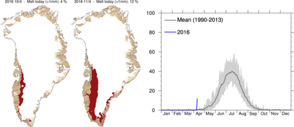

Record Early Start to Greenland Melt Season
(Record early start to Greenland’s ‘Summer’ melt season occurred on April 11, 2016 according to reports from DMI’s Polar Portal.)

Yesterday’s new record early melt start occurred as extraordinarily warm temperatures in the range of 20-40 degrees Fahrenheit above average swept over southern, central and western Greenland. This flood of extremely warm temperatures for Greenland was accompanied by heavy rains and strong winds — gusting to gale or even hurricane force in some locations. In some areas, rain fell over the ice sheet itself. As recently as midday Tuesday, Dr. Jason Box — a prominent Greenland researcher — tweeted a report from a friend in Nuuk that the city was “close to drowning in water caused by rain and snow melt.”

Close to drowning in water from the rain and snow-melt. Sounds like parts of Louisiana which flooded this past March, especially western Saint Tammany Parish, which almost drowned from the historic flash floods there. So it looks like Nuuk is having flash floods from this North Atlantic gale that's melting a lot of snow and ice with its extraordinary amount of rain.

Raúl Ilargi Meijer of The Automatic Earth says the above graphic is the "Scary graph of the day."

Greenland’s Melt Season Started Nearly Two Months Early (CC)
Brian Kahn, Climate Central. 12 April 2016
To say the 2016 Greenland melt season is off to the races is an understatement. Warm, wet conditions rapidly kicked off the melt season this weekend, more than a month-and-a-half ahead of schedule. It has easily set a record for earliest melt season onset, and marks the first time it’s begun in April. Little to no melt through winter is the norm as sub-zero temperatures keep Greenland’s massive ice sheet, well, on ice. Warm weather usually kicks off the melt season in late May or early June, but this year is a bit different. Record warm temperatures coupled with heavy rain mostly sparked 12% of the ice sheet to go into meltdown mode. Almost all the melt is currently centered around southwest Greenland.
....

According to Polar Portal, which monitors all things ice-related in the Arctic, melt season kicks off when 10% of the ice sheet experiences surface melt. The previous record for earliest start was May 5, 2010. This April kickoff is so bizarrely early, scientists who study the ice sheet checked their analysis to make sure something wasn’t amiss before making the announcement. “We had to check that our models were still working properly” Peter Langen, a climate scientist at the Denmark Meteorological Institute (DMI), told the Polar Portal. But alas, the models are definitely working and weather data and stories coming out of West Greenland have borne that out. According to DMI, temperatures at Kangerlussuaq, a small village in southwest Greenland, set an April record for that location when they reached 64.4°F (17.8°C) on Monday. That’s just a scant .4°F (.2°C) off the all-time Greenland high for April. Heavy rain have also inundated local communities.
And that's not the scariest graph! One of the commenters at The Automatic Earth, Nassim, yesterday found an even scarier graph! One that shows a lot of basal melt under the central region and north side of Greenland's ice cap:

http://joannenova.com.au/2016/04/hot-magma-is-melting-greenland-ice-can-windfarms-save-it/

And he left this comment:

About Greenland and that “scary graph”, here is an alternative explanation:

“Ice-penetrating radar and ice core drilling have shown that large parts of the north-central Greenland ice sheet are melting from below. It has been argued that basal ice melt is due to the anomalously high geothermal flux that has also influenced the development of the longest ice stream in Greenland. Here we estimate the geothermal flux beneath the Greenland ice sheet and identify a 1,200-km-long and 400-km-wide geothermal anomaly beneath the thick ice cover. We suggest that this anomaly explains the observed melting of the ice sheet’s base, which drives the vigorous subglacial hydrology3 and controls the position of the head of the enigmatic 750-km-long northeastern Greenland ice stream. Our combined analysis of independent seismic, gravity and tectonic data implies that the geothermal anomaly, which crosses Greenland from west to east, was formed by Greenland’s passage over the Iceland mantle plume between roughly 80 and 35 million years ago. We conclude that the complexity of the present-day subglacial hydrology and dynamic features of the north-central Greenland ice sheet originated in tectonic events that pre-date the onset of glaciation in Greenland by many tens of millions of years.”
Well what's causing all that magma flow? Could it be that it's being drawn in by the seismic uplift of the island due to loss of solid ice mass ALREADY!?! We do know there has been seismic activity around the island in recent years. Or is the ice-melt from below mainly due to the incoming water from the moulins bleus introduced by surface melt during the summer months? Or a combination of the two? Inquiring minds want to know. I'll refer this to Robertscribbler.